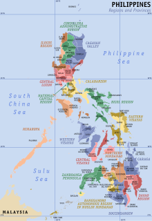
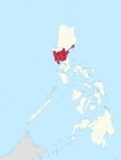
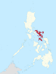
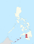
Regions of the Philippines
| Regions of the Philippines | |
|---|---|
 Administrative map of the Philippines | |
| Category | Region |
| Location | Philippines |
| Number | 18 (as of 2024) |
| Possible status |
|
| Populations | Smallest: 1,791,121 (CAR) Largest: 16,139,770 (Calabarzon) |
| Areas | Smallest: 636.00 km2 (245.56 sq mi) (NCR) Largest: 29,620.90 km2 (11,436.69 sq mi) (Mimaropa) |
| Government |
|
| Subdivisions | |
 |
|---|
|
|
In the Philippines, regions (Filipino: rehiyon; ISO 3166-2:PH) are administrative divisions that primarily serve to coordinate planning and organize national government services across multiple local government units (LGUs). Most national government offices provide services through their regional branches instead of having direct provincial or city offices. Regional offices are usually but not necessarily located in the city designated as the regional center.
As of 2024, the Philippines is divided into 18 regions. Seventeen of these are mere administrative groupings, each provided by the president of the Philippines with a regional development council (RDC) – in the case of the National Capital Region (Metro Manila), an additional metropolitan development authority serves as the coordinating and policy-making body. Only one, the Bangsamoro Autonomous Region in Muslim Mindanao, has an elected government and parliament to which the Congress of the Philippines has delegated certain powers and responsibilities.
History
[edit]Regions first came to existence on September 24, 1972, when the provinces of the Philippines were organized into eleven regions under Presidential Decree No. 1 as part of the Integrated Reorganization Plan of President Ferdinand Marcos.[1] Since that time, other regions have been created and some provinces have been transferred from one region to another.
Timeline
[edit]- June 22, 1973 – Pangasinan is transferred from Region III (Central Luzon) to Region I (Ilocos Region).[2]
- July 7, 1975 – Region XII is created, and some regions of Mindanao are reorganized.[3]
- July 25, 1975 – Regions IX and XII are declared as Autonomous Regions in Western and Central Mindanao, respectively.[4]
- August 21, 1975 – Region IX is divided into Sub-Region IX-A and Sub-Region IX-B. Some regions in Mindanao are reorganized.[5]
- November 7, 1975 – Metro Manila is created.[6]
- January 23, 1976 – Metro Manila is separated from Southern Tagalog to become Region IV; Southern Tagalog becomes Region IV-A.[7]
- June 2, 1978 – Metro Manila is declared the National Capital Region.[8]
- June 11, 1978 – The regional center of Region IX is transferred from Jolo, Sulu to Zamboanga City.[9]
- July 15, 1987 – The Cordillera Administrative Region is created.[10]
- August 1, 1989 – The Autonomous Region in Muslim Mindanao (ARMM) is created.[11] Region XII reverted to an administrative region.
- January 30, 1990 – Residents reject in a plebiscite the ratification to create the Cordillera Autonomous Region.[12]
- October 12, 1990 – Reorganization and/or renaming of the Mindanao regions: Region IX (Western Mindanao), Region X (Northern Mindanao), Region XI (Southern Mindanao), Region XII (Central Mindanao), and ARMM. Regional center of Region IX is transferred to Pagadian, with Zamboanga City remaining as the region's commercial and industrial center.[13]
- February 23, 1995 – Region XIII (Caraga) is created and minor reorganization of some Mindanao regions; Sultan Kudarat is transferred to Region XII.[14]
- March 7, 1998 – Residents reject in a plebiscite for the second time the ratification to create the Cordillera Autonomous Region.[15]
- December 18, 1998 – Sultan Kudarat is reverted to Region XII.[16]
- March 31, 2001 – The ARMM is expanded.[17]
- September 19, 2001 – Most Mindanao regions are reorganized and some are renamed, such as Region IX (Zamboanga Peninsula), Region XI (Davao Region), and Region XII (Soccsksargen).[18]
- May 17, 2002 – Region IV-A (Calabarzon) and Region IV-B (Mimaropa) are created from the former Region IV (Southern Tagalog) region; Aurora is transferred to Region III.[19]
- October 28, 2003 – Calamba, Laguna is designated as the regional center of Region IV-A.[20]
- March 30, 2004 – Koronadal is designated as the regional center of Region XII.[21]
- May 23, 2005 – Palawan is transferred from Region IV-B to Region VI (Western Visayas).[22]
- August 19, 2005 – The transfer of Palawan to Region VI is held in abeyance.[23]
- November 22, 2007 – Calapan is designated as the regional center of Region IV-B.[24]
- May 29, 2015 – The Negros Island Region (NIR) is created. Negros Occidental and Bacolod are transferred from Region VI, and Negros Oriental is removed from Region VII (Central Visayas).[25]
- July 17, 2016 – The Southwestern Tagalog Region (Mimaropa Region) is established comprising the former Region IV-B (in effect merely a renaming and discontinuation of the "Region IV-B" designation since no boundary changes were involved).[26]
- August 9, 2017 – NIR abolished. Negros Occidental (including Bacolod) and Negros Oriental reverted to Regions VI and VII, respectively.[27]
- January 25, 2019 – The Bangsamoro Autonomous Region in Muslim Mindanao (BARMM) is created, replacing the ARMM after the ratification of the Bangsamoro Organic Law.[28][29][30]
- June 11, 2024 - NIR re-established, with Siquijor transferred from Region VII.[31][32]
- September 9, 2024 - Sulu is declared not part of the BARMM.[33]
List of regions
[edit]As of June 30, 2024[update], the Philippines is divided into 18 regions.[34] The traditional island groups of Luzon, the Visayas, and Mindanao are composed of eight (Regions I, II, III, IV-A, and V, and CAR, NCR, and Mimaropa), four (VI, VII, VIII, and NIR), and six (IX, X, XI, XII, XIII, and BARMM) regions, respectively. The names of Calabarzon, Mimaropa, and Soccsksargen are acronyms signifying their component provinces and cities; and are usually capitalized in official government documents.
Types of regions
[edit]Administrative region
[edit]An administrative region is a grouping of geographically adjacent LGUs that may be established, disestablished, and modified by the president of the Philippines based on the need to formulate coherent economic development policies, more efficiently provide national government services, and coordinate activities beneficial to the development of larger area beyond the province level. No plebiscites have been conducted so far to democratically confirm the creation, abolition or alteration of the boundaries of regular administrative regions, as the Constitution does not mandate it.[35]
An administrative region is not a local government unit (LGU), but rather a group of LGUs to which the president[36] has provided an unelected policy-making and coordinating structure, called the Regional Development Council (RDC).[37] Metro Manila is recognized in law as a "special development and administrative region", and was thus given the Metropolitan Manila Development Authority (MMDA);[38] the Metro Manila Council within the MMDA serves as the National Capital Region's RDC.[37]
Autonomous region
[edit]The 1987 Constitution allows for the creation of autonomous regions in the Cordillera Central of Luzon and the Muslim-majority areas of Mindanao.[35] However, only the Bangsamoro Autonomous Region in Muslim Mindanao and its predecessor, the Autonomous Region in Muslim Mindanao, have been approved by voters in plebiscites held in 1989, 2001, and 2019. Voters in the Cordilleras rejected autonomy in 1990 and 1998; hence the Cordillera Administrative Region remains as a regular administrative region with no delegated powers or responsibilities.
The Supreme Court has ruled that an autonomous region established by statute must be composed of more than one province, thereby invalidating the proposed establishment of the Autonomous Region of Ifugao following the results of the original 1990 Cordillera autonomy plebiscite, which saw only Ifugao's voters casting a majority 'yes' vote towards autonomy.[39]
Table of regions
[edit]- Component local government units: the data column is limited to primary LGUs, which pertains to component provinces, highly urbanized cities, and independent component cities, as well as the independent municipality of Pateros. All city names, except those under the National Capital Region, are italicized.
- Location: the location map column can be sorted from north-to-south, west-to-east.
| Location | Region (regional designation) |
PSGC[40] | Island group |
Regional center |
Component local government units |
Area[a] | Population (2020)[44] |
Density | |
|---|---|---|---|---|---|---|---|---|---|

|
National Capital Region (NCR) |
13 | Luzon | Manila | 636.00 km2 (245.56 sq mi) |
13,484,462 (12.41%) |
20,247/km2 (52,440/sq mi) | ||

|
Cordillera Administrative Region (CAR) |
14 | Luzon | Baguio | 19,422.03 km2 (7,498.89 sq mi) |
1,791,121 (1.65%) |
89/km2 (230/sq mi) | ||

|
Ilocos Region (Region I) |
01 | Luzon | San Fernando | 13,012.60 km2 (5,024.19 sq mi) |
5,292,297 (4.87%) |
386/km2 (1,000/sq mi) | ||

|
Cagayan Valley (Region II) |
02 | Luzon | Tuguegarao | 28,228.83 km2 (10,899.21 sq mi) |
3,679,748 (3.39%) |
122/km2 (317/sq mi) | ||

|
Central Luzon (Region III) |
03 | Luzon | San Fernando | 22,014.63 km2 (8,499.90 sq mi) |
12,387,811 (11.40%) |
510/km2 (1,320/sq mi) | ||

|
Calabarzon (Region IV-A) |
04 | Luzon | Calamba | 16,873.31 km2 (6,514.82 sq mi) |
16,139,770 (14.85%) |
854/km2 (2,213/sq mi) | ||

|
Southwestern Tagalog Region (Mimaropa)[d] |
17 | Luzon | Calapan | 29,620.90 km2 (11,436.69 sq mi) |
3,212,287 (2.96%) |
100/km2 (259/sq mi) | ||

|
Bicol Region (Region V) |
05 | Luzon | Legazpi | 18,155.82 km2 (7,010.00 sq mi) |
6,067,290 (5.58%) |
319/km2 (827/sq mi) | ||

|
Western Visayas (Region VI) |
06 | Visayas | Iloilo City | 12,750.63 km2 (4,923.05 sq mi) |
4,730,771 (4.35%) |
371/km2 (961/sq mi) | ||

|
Negros Island Region (NIR) |
18 | Visayas | Bacolod and Dumaguete (interim/de facto) |
13,525.56 km2 (5,222.25 sq mi) |
4,760,340 (4.38%) |
352/km2 (912/sq mi) | ||

|
Central Visayas (Region VII) |
07 | Visayas | Cebu City | 10,114.52 km2 (3,905.24 sq mi) |
6,545,603 (6.02%) |
647/km2 (1,676/sq mi) | ||

|
Eastern Visayas (Region VIII) |
08 | Visayas | Tacloban | 23,251.10 km2 (8,977.30 sq mi) |
4,531,512 (4.17%) |
191/km2 (495/sq mi) | ||

|
Zamboanga Peninsula (Region IX) |
09 | Mindanao | Pagadian | 17,056.73 km2 (6,585.64 sq mi) |
3,862,588 (3.55%) |
213/km2 (551/sq mi) | ||

|
Northern Mindanao (Region X) |
10 | Mindanao | Cagayan de Oro | 20,496.02 km2 (7,913.56 sq mi) |
5,007,798 (4.61%) |
229/km2 (593/sq mi) | ||

|
Davao Region (Region XI) |
11 | Mindanao | Davao City | 20,357.42 km2 (7,860.04 sq mi) |
5,223,802 (4.81%) |
245/km2 (634/sq mi) | ||

|
Soccsksargen (Region XII) |
12 | Mindanao | Koronadal | 22,513.30 km2 (8,692.43 sq mi) |
4,351,773 (4.0%) |
202/km2 (523/sq mi) | ||

|
Caraga (Region XIII) |
16 | Mindanao | Butuan | 21,478.35 km2 (8,292.84 sq mi) |
2,795,340 (2.57%) |
121/km2 (313/sq mi) | ||

|
Bangsamoro (BARMM)[g] |
19 | Mindanao | Cotabato City | 11,935.7 km2 (4,608.4 sq mi) |
3,944,692 (3.63%) |
330/km2 (856/sq mi) | ||
Notes
| |||||||||
Judicial regions
[edit]As far as the judiciary is concerned, specifically the first and second level courts, the country is divided into judicial regions as provided by Batas Pambansa Bilang 129. The coverage of these judicial regions generally coincides with that of the administrative regions in 1980, with some exceptions.
Legislative districts
[edit]Representation for the Interim Batasang Pambansa was mostly through parliamentary districts based on how regions were organized in 1978. Metro Manila was "Region IV", while Southern Tagalog was "Region IV-A". This was the only time the national legislature was represented via regions; in a 1984 plebiscite, voters approved a constitutional amendment that reverted to representation per province and city.
Proposed regions
[edit]- Cordillera Autonomous Region[45] (proposal to convert the Cordillera Administrative Region into an autonomous region; see Cordillera autonomy movement)
- Samar Administrative Region[46]
- Bangsa Sug[47][48][49] or Basulta Autonomous Region[50] (proposed to separate the Sulu Archipelago from the mainland portion of Bangsamoro)
Defunct regions
[edit]The following are regions that no longer exist, listed along with their current status:
- Southern Tagalog (Region IV, now divided into Calabarzon, Central Luzon (Aurora), Metro Manila (several cities that were part of Rizal), and Mimaropa; the name remains as a cultural-geographic region only)
- Western Mindanao (renamed as Zamboanga Peninsula, still designated as Region IX)
- Central Mindanao (now mostly Soccsksargen, still designated as Region XII)
- Southern Mindanao (now mostly Davao Region, still designated as Region XI)
- Autonomous Region in Muslim Mindanao (replaced by Bangsamoro)
See also
[edit]- List of regions of the Philippines by GDP
- Super regions of the Philippines
- Federalism in the Philippines
- ISO 3166-2:PH
References
[edit]- ^ Integrated Reorganization Plan: Reorganization of the Executive Branch of the National Government. Presidential Commission on Reorganization. 1972. pp. 12–13.
- ^ "Presidential Decree No. 224". Retrieved November 5, 2016.
- ^ "Presidential Decree No. 742; Restructuring the Regional Organization of Mindanao, Basilan, Sulu and Tawi-Tawi". The Lawphil Project. July 7, 1975. Retrieved June 6, 2015.
- ^ "Presidential Decree No. 1618; Implementing the Organization of the Sangguniang Pampook and the Lupong Tagapagpaganap ng Pook in Region IX and Region XII and for Other Purposes". The Lawphil Project. July 25, 1975. Retrieved June 6, 2015.
- ^ "Presidential Decree No. 773; Amending Presidential Decree No. 742 Restructuring the Regional Organization of Mindanao and Dividing Region IX into Two Sub-regions". The Lawphil Project. August 21, 1975. Retrieved June 6, 2015.
- ^ "Presidential Decree No. 824; Creating the Metropolitan Manila and the Metropolitan Manila Commission and for Other Purposes". The Lawphil Project. November 7, 1975. Retrieved June 6, 2015.
- ^ "Presidential Decree No. 879 – Dividing Region No. 4 of the Administrative Field Organization of the Various Departments and Agencies of the Government Into Region No. 4 and 4-A". Supreme Court E-Library. President of the Philippines. January 23, 1976. Retrieved May 16, 2023.
- ^ "Presidential Decree No. 1396, s. 1978; Creating the Department of Human Settlements and the Human Settlement Development Corporation, Appropriation Funds Therefor, and Accordingly Amending Certain Presidential Decrees". Official Gazette of the Republic of the Philippines. June 2, 1978. Retrieved September 22, 2015.
- ^ "Presidential Decree No. 1555: Further Amending Presidential Decree No. 742 as amended by Presidential Decree No. 773 transferring the regional center of Region IX from Jolo to Zamboanga City". The LawPhil Project. June 11, 1978. Retrieved June 12, 2020.
- ^ "Executive Order No. 220; Creating a Cordillera Administrative Region, Appropriating Funds Therefor and for Other Purposes". The Lawphil Project. July 15, 1987. Retrieved June 6, 2015.
- ^ "Republic Act No. 6734; An Act Providing for an Organic Act for the Autonomous Region in Muslim Mindanao". The Lawphil Project. August 1, 1989. Retrieved June 6, 2015.
- ^ "Republic Act No. 6766; An Act Providing for an Organic Act for the Cordillera Autonomous Region". The Lawphil Project. October 23, 1989. Retrieved June 6, 2015.
- ^ "Executive Order No. 429 s. 1990; Providing for the Reorganization of the Administrative Regions in Mindanao, and for Other Purposes". The Lawphil Project. October 12, 1990. Retrieved June 6, 2015.
- ^ "Republic Act No. 7901; An Act Creating Region XIII to be Known as the Caraga Administrative Region, and for Other Purposes". Chan Robles Virtual Law Library. February 23, 1995. Retrieved June 6, 2015.
- ^ "Republic Act No. 8438; An Act to Establish the Cordillera Autonomous Region". The Lawphil Project. December 22, 1997. Retrieved June 6, 2015.
- ^ "Republic Act No. 8744; An Act Repealing Section 3 of Republic Act No 7901 and to Return the Province of Sultan Kudarat to Region XII and for Other Purposes". The Lawphil Project. December 18, 1998. Retrieved June 6, 2015.
- ^ "Republic Act No. 9054; An Act to Strengthen and Expand the Organic Act for the Autonomous Region in Muslim Mindanao, Amending for the Purpose Republic Act No. 6734, Entitled "An Act Providing for the Autonomous Region in Muslim Mindanao," as Amended". The Lawphil Project. March 31, 2001. Retrieved June 6, 2015.
- ^ "Executive Order No. 36; Providing for the Reorganization of the Administrative Regions in Mindanao and for Other Purposes". The Lawphil Project. September 19, 2001. Retrieved June 6, 2015.
- ^ "Executive Order No. 103; Dividing Region IV into Region IV-A and Region IV-B, Transferring the Province of Aurora to Region III and for Other Purposes". The Lawphil Project. May 17, 2002. Retrieved June 6, 2015.
- ^ "Executive Order No. 246, October 28, 2003; Designating Calamba City as Regional Center of Region IV-A (Calabarzon)". The Lawphil Project. October 28, 2003. Retrieved June 18, 2024.
- ^ Executive Order No. 304 (March 30, 2004), Designating Koronadal City as the Regional Center and Seat of Soccsksargen, The Lawphil Project, retrieved June 23, 2024.
- ^ "Executive Order No. 429; Providing for the Reorganization of Administrative Region VI to Include the Province of Palawan and Puerto Princesa City". The Lawphil Project. May 23, 2005. Retrieved June 6, 2015.
- ^ Administrative Order No. 129 (August 19, 2005), Directing the Department of the Interior and Local Government to Hold in Abeyance the Implementation of Executive Order No. 429 (s. 2005) Pending Its Submission of an Implementation Plan and Its Subsequent Approval By the Office of the President, The Lawphil Project, retrieved June 23, 2024
- ^ Executive Order No. 682 (November 22, 2007), Designating Calapan City as the Regional Center of Region IV-B Otherwise Referred to as the MIMAROPA Region (PDF), The Official Gazette, retrieved June 18, 2024
- ^ "Executive Order No. 183, s. 2015; Creating a Negros Island Region and for Other Purposes". Official Gazette (Philippines). May 29, 2015. Retrieved June 6, 2015.
- ^ "An Act establishing the Southwestern Tagalog Region, to be known as the MIMAROPA Region". July 17, 2016. Retrieved January 4, 2017.
- ^ "Executive Order No. 38, August 07, 2017 - Revoking Executive Order No. 183 (s. 2015) Which Created A Negros Island Region And For Other Purposes". The Lawphil Project. August 7, 2017. Retrieved June 18, 2024.
- ^ "Comelec ratifies Bangsamoro Organic Law". BusinessMirror. January 26, 2019. Retrieved February 6, 2019.
- ^ Depasupil, William; Reyes, Dempsey (January 23, 2019). "'Yes' vote prevails in 4 of 5 provinces". The Manila Times. Retrieved January 26, 2019.
- ^ Galvez, Daphne (January 22, 2019). "Zubiri: Overwhelming 'yes' vote for BOL shows Mindanao shedding its history of conflict". Philippine Daily Inquirer. Retrieved January 26, 2019.
- ^ Republic Act No. 12000 (June 11, 2024), An Act Establishing the Negros Island Region (PDF), Official Gazette (Philippines), retrieved June 19, 2024
- ^ de Leon, Dwight (June 13, 2024). "Marcos signs law creating new Negros Island Region". Rappler. Retrieved June 13, 2024.
- ^ "SC Upholds Validity of Bangsamoro Organic Law; Declares Sulu not Part of Bangsamoro Region". Supreme Court of the Philippines. September 9, 2024. Retrieved September 9, 2024.
- ^ "Number of provinces, cities, municipalities and barangays, by region, as of 30 June 2024" (XLSX). PSGC. Philippine Statistics Authority. Retrieved July 13, 2024.
- ^ a b Republic of the Philippines (1987). "The 1987 Constitution of the Philippines – Article X, Local Government". The Official Gazette of the Republic of the Philippines. Retrieved August 9, 2019.
- ^ Fidel V. Ramos (April 12, 1996). "Executive Order No. 325, Series of 1996". The Official Gazette of the Republic of the Philippines. Retrieved August 9, 2019.
- ^ a b "FAQs – The Regional Development Council" (PDF). National Economic and Development Authority. November 2018. Retrieved August 11, 2019.
- ^ Congress of the Philippines (March 1, 1995). "Republic Act No. 7924 – An Act Creating Metropolitan Manila Development Authority, Defining Its Powers And Function, Providing Funds Therefor And Other Purposes" (PDF). Retrieved August 9, 2019.
- ^ "G.R. No. 93054. December 4, 1990. Cordillera Regional Assembly Member Alexander P. Ordillo, (Banaue), Ifugao Provincial Board Member Corazon Montinig, (Mayoyao), Former Vice Mayor Martin Udan (Banaue), Municipal Councilors Martin Gano, (Lagawe), and Teodoro Hewe, (Hingyon), Barangay Councilman Pedro W. Dulag (Lamut); Aguinaldo Residents Sandy B. Changiwan, and Donato Timago; Lamut Resident Rey Antonio; Kiangan Residents Orlando Puguon, and Reynand Duldulao; Lagawe Residents Tomas Kimayong, Gregorio Dango, George B. Baywong, and Vicente Lunag; Hingyon Residents Pablo M. Dulnuan and Constancio Gano; Mayoyao Residents Pedro M. Baoang, Leonardo Igadna, and Maximo Igadna; and Banaue Residents Puma-a Culhi, Latayon Buttig, Miguel Pumelban, Andres Ordillo, Federico Mariano, Sandy Binomnga, Gabriel Limmang, Romeo Tongali, Ruben Bahatan, Mhomdy Gabriel, and Nadres Ghamang, Petitioners, V. The Commission on Elections; the Franklin M. Drilon, Secretary of Justice; Catalino Macaraig, Executive Secretary; the Cabinet Officer for Regional Development; Guillermo Carague, Secretary of Budget and Management; and Rosalina S. Cajucom, OIC, National Treasurer, Respondents". ChanRobles Law Library. December 4, 1990. Retrieved August 9, 2019.
- ^ "Provincial Summary Number of Provinces, Cities, Municipalities and Barangays, by Region". Philippine Statistics Authority. June 30, 2024. Retrieved July 13, 2024.
- ^ "PSGC Interactive; List of Provinces". Philippine Statistics Authority. Retrieved April 3, 2016.
- ^ "PSGC Interactive; List of Cities". Philippine Statistics Authority. Retrieved April 7, 2016.
- ^ For provinces in the ARMM: "Bangsamoro Development Plan Integrative Report, Chapter 10" (PDF). Bangsamoro Development Agency. 2015. Retrieved May 31, 2016.[dead link]
- ^ "Household Population, Number of Households, and Average Household Size of the Philippines (2020 Census of Population and Housing)". Philippine Statistics Authority. May 24, 2022. Retrieved May 24, 2022.
- ^ "Cordillera Solons expressed views on regional autonomy". National Economic and Development Authority – Cordillera Administrative Region. August 12, 2013. Retrieved February 28, 2015.
- ^ "Bishops call for separate Samar administrative region". GMA News. June 15, 2016. Retrieved September 18, 2017.
- ^ "Sulu Sultanate, Bangsa Sug push revision of BBL". Sun-Star. May 10, 2018. Retrieved August 31, 2018.
- ^ "Why is autonomy tied to peace talks?". Inquirer.net. August 18, 2015. Retrieved August 31, 2018.
- ^ "10,000 people to benefit from Bangsa Sug Iftar Caravan in Zamboanga City". Mindanao Examiner. May 23, 2018. Retrieved August 31, 2018.
- ^ Zurbano, Joel (November 19, 2024). "Padilla seeks new autonomous region for Sulu". Manila Standard. Retrieved November 21, 2024.


